Posts

Showing posts with the label ArcGIS

Layers JSON: Giving LLMs the GIS Context They Need

When I started writing about GenAI and geospatial analysis , the attraction was being able to ask questions in plain language and let the tools do the spatial work. There is a very practical detail behind that interaction, though: the model needs to know what our data means. Take a field called STATUS with a value of 3 . Is that an active well? An abandoned one? A record waiting for review? A model can write perfectly valid SQL around that number and still give us the wrong answer. The database will happily execute it, too :-) That is the problem I want to address with layers-json : give applications access to the knowledge already captured in an ArcGIS Pro project and its supporting data sources. The map already carries a lot of the explanation If you have spent time giving fields useful aliases, defining domains, and organizing layers in Pro, you have already done some of the hard work. A field alias turns a storage name into something a person recognizes. A coded-value doma...

On Machine Learning in ArcGIS and Data Preparation using Spark

Image
Artificial Intelligence / Machine Learning implementations have been part of Esri software in ArcGIS for a very long time. Geographic Weighted Regression (GWR) and Hot Spot Analysis are Machine Learning algorithms. ArcGIS users have been utilizing supervised and   unsupervised learning like clustering  to solve a myriad of problems and gain geospatial insight from their data.  We just did not call these learning algorithms AI/ML back then.  Not until the recent popularity of DeepLearning that finally blossomed from the AI Winter  and made AI a household name. And guess what? Esri software has now DeepLearning implementations ! It is important to understand the difference between AI, ML, and DL.  I came across this very insightful article that analogizes the relationship to Russian dolls . Typically, collected data is very "dirty", and a lot of cleaning has to performed on it before processing it through a Machine Learning algorithm.  The bigger ...

ArcGIS Pro, Jupyter Notebook and Databricks

Yet another post in the continuing saga of the usage of Apache Spark from a Jupyter notebook within ArcGIS Pro . In the previous posts , the execution was always within the ArcGIS Pro environment on a single machine, albeit taking advantage of all the cores of that machine.  Here, we take a different angle, the execution is performed on a remote cluster of machines in the cloud. So, we author the notebook locally, but we execute it remotely. In this notebook, we demonstrate the spatial binning of AIS broadcast points on a Databricks cluster on Azure . In addition, to colocate the data storage with the execution engine for performance purposes, we converted the local feature class of the AIS broadcast points to a parquet file and placed it in the Databricks distributed file system . More to come :-)

ArcGIS, Spark and Alluxio Integration

Image
There exist a plethora of backend distributed data stores. I am always using S3 or Hadoop HDFS or OpenStack Swift with my GIS applications to read from these backends geospatial data or to save into these backends my data. Some of these distributed data stores are not natively supported by the ArcGIS platform . However, the platform can be extended with ArcPy to handle these situations. Depending on the data store, I will have to use a different API (mostly Python based) to read and write geospatial information. This is where Alluxio comes in very handy. It provides an abstract layer between the application and the data store and (here is the best part), it caches this information in memory in a distributed and resilient-to-failure manner. So, at the application level, the code to access the data is invariant. On the backend, I can configure Alluxio to use either S3, HDFS or SWIFT. Finally, the advent of a REST endpoint in Alluxio eases the integration with ArcGIS to write, read ...

ArcGIS, Spark & MemSQL Integration

Image
Just got back from the fantastic Strata + Hadoop 2017 conference where the topics ranged from BigData, Spark to lots of AI/ML and not so much on Hadoop explicitly, at least not in the sessions that I attended. I think that is why the conference is renamed Strata + Data from now on as there is more to Hadoop in BigData. While strolling the exhibition hall, I walked into the booth of our friends at MemSQL and got a BIG hug from Gary . We reminisced about our co-presentations at various conferences regarding the integration of ArcGIS and MemSQL as they natively support geospatial types. This post is a refresher on the integration with a "modern" twist, where we are using the Spark Connector to ETL geo spatial data into MemSQL in a Docker container. To view the bulk loaded data, ArcGIS Pro is extended with an ArcPy toolbox to query MemSQL, aggregate and view the result set of features on a map. Like usual, all the source code can be found here

Space Time Ripples

Image
Start by looking at this application and that one. Make sure to tilt the map by holding down the right mouse button and sliding the mouse up. Then, slide the bottom slider back and forth to see the data "ripple" through time. This type of visualization is something I have wanted to do for a long time and is now possible with the advent of the new 4.2 ArcGIS API for JavaScript . The new API has "hooks" to enable a developer to invoke WebGL shaders directly, which can render a massive amount of data very efficiently and very quickly. The authoring of the data for the above applications is based on ArcGIS Pro extended with a custom ArcPy based toolbox. The tool queries features from a user selected feature class, bins the features by space and time and emits a space-time "cube" in the form of a Dojo AMD module to be loaded by a JavaScript application. The source of the feature class can be a geodatabase, a relational data store, or the new Spatia...

Snapping Points To Lines And ArcGIS Pro

Image
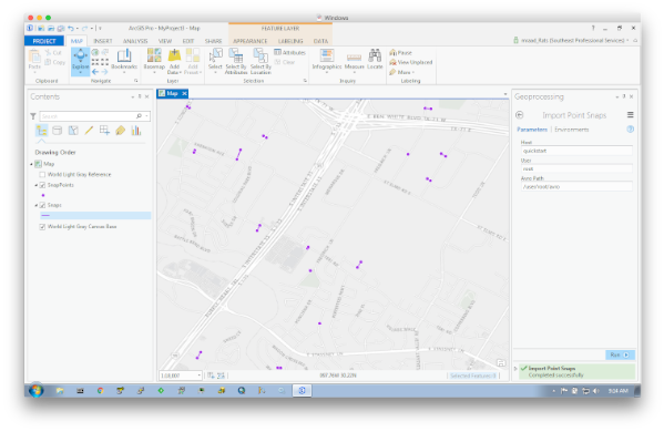
Been wanting to post on this subject for quite some time (actually over a year) as associating a world coordinate with the proper nearby linear feature provides tremendous insight based on the fusion of their attributes. Moreover, doing that on a massive scale and quickly is even more imperative in today's BigData world, thus the usage of Apache Spark . I’ve posted a standalone implementation that relies on well-documented simple math and published methodology to perform searches on massive datasets in batch mode. What is exciting to me in writing this post was the viewing of the snap results in ArcGIS Pro . My lack of knowledge in extending ArcGIS Pro with downloadable Python modules contributed to the delay (and slight case of procrastination :-). However, with the help of a colleague, I was able to pip install modules that can be imported by my custom ArcPy based toolboxes without any errors. Also, since this is all based on BigData, well it has to be tested in a BigData e...

ArcGIS For Server On Docker

“But…It works on _my_ machine !!!” How many times did you hear that ? That is exactly one of the use cases of Docker for developers - Create an exact reproducible environment for each developer, even down to the hardware specification. And, that same environment can be on premise or in the cloud. With the advent of ArcGIS For Server 10.4 , I wanted to run it on my mac so I can try out some of the new features like chaining multiple SOIs. I could have started a Windows based VM and gone through the GUI based setup, which is a pretty straight forward process (My friend Georges G. calls this, a PhD process, P ush H ere D ummy). But, I wanted to automate the whole install process in a headless way (I’m sure there is a way to do that using Windows, just I do not know how, maybe a blog post for another day) Enter Docker. After downloading the ArcGIS For Linux tarball and the license file from my.esri.com , you can build a Dockerfile that automates the whole install process in a headless wa...

Spark Library To Read File Geodatabase

Happy 2016 all. Yes it has been a while and thanks for your patience. Like usual, at the beginning of every year, there are the promises to eat less, exercise more, climb Ventoux and blog more. Was listening to Feakonomic (When Willpower Isn’t Enough) , and this initial post of the year is to harness the power of a fresh start. Esri has been advocating for a while to use FileGeodatabase , and actually released a C++ based API to perform read-only operations on it. However, the read has to be performed off a local file system and the read is single threaded (you could write an abstract layer on top of the API to perform a parallel partitioned read if you have the time). In my BigData uses cases, I need to place the GDB files in HDFS so I can perform Spark based GeoAnalytics. Well, that made the usage of the C++ API difficult (as it is not using the Hadoop File System API) and will have to map the Spark API to a native API and will have to publish the DLL and…(well you can imagine ...

Bulk Load Features from ArcGIS Into Elasticsearch

Image
I really like Elasticsearch because it natively supports geo spatial types and queries. I just added to gitbub a ArcPy based toolbox to bulk load the content of a feature class into an ES index/type. The toolbox contains yet another tool as a proof-of-concept to spatially query the loaded document.

BigData Point-In-Polygon GeoEnrichment

I’m always handed a huge set of CSV records with lat/lon coordinates, and the task at hand is to spatially join these records with a huge set of feature polygons where the output is a geoenhancement of the orignal points with the intersecting polygon’s attributes. An example is a set of retailer customer locations that need to be spatially intersected with demographic polygons for targeted advertisement (Sorry to send you all more junk mail :-). This is a reference implementation, where both the points data and the polygon data are stored in raw text TSV format and the polygon geometries are in WKT format. Not the most efficient format, but at least the input is splittable for massive parallelization. The feature class polygons can be converted to WKT using this ArcPy tool. This Spark based job can be executed in local mode, or better in this docker container. One of these days will have to re-implement the reading of the polygons from a binary source such as shapefiles or file g...

BigData, MemSQL and ArcGIS Interceptors

Image
Last week, at the Developer Summit , we unveiled Server Object Interceptors. They have the same API as Server Object Extensions , and are intended to extend an ArcGIS Server with custom capabilities. An SOI intercepts REST and/or SOAP calls on a MapServer before and/or after it executes the operation on an SOE or SO. Think servlet filters. A use case of an SOI associated with a published MXD is to intercept an export image operation on its MapService and digitally watermark the original resulting image. Another use case of an interceptor is to use the associated user credentials in the single-sign-on request to restrict the visibility of layers or data fields. This is pretty neat and being the BigData Advocate, I started thinking how to use this interceptor in a BigData context. The stars could not have been more aligned than when I heard that the MemSQL folks have announced geospatial capabilities in their InMemory database.  See, I knew for a while that they were spitb...

Spark, Cassandra, Tessellation and ArcGIS

Image
If you do BigData and have not heard or used Spark then…..you are living under a rock! When executing a Spark job, you can read data from all kind of sources with schemas like file, hdfs, s3 and can write data to all kind of sinks with schemas like file and hdfs. One BigData repository that I’ve been exploring is Cassandra .  The DataStax folks released a Cassandra connector to Spark enabling the reading and writing of data from and to Cassandra. I’ve posted on Github a sample project that reads the NYC trip data from a local file and tessellates a hexagonal mosaic with aggregates of pickup locations.  That aggregation is persisted onto Cassandra. To visualize the aggregated mosaic, I extended ArcMap with an ArcPy toolbox that fetches the content of a Cassandra table and converts it to a set of features in a FeatureClass. The resulting FeatureClass is associated with a gradual symbology to become a layer on the map as follows: Like usual all the source code is he...

Apache Spark, Spatial Functions and ArcGIS for Desktop

Image
A while back I watched with great fascination a webinar presented by UC Berkley amp lab  on Spark and Shark . I wanted to spatially enable spark and has been on my todo list for a while. Spark has “graduated” and has joined the real world as databricks  and has raise some serious cash to take on map reduce . Even Cloudera is teaming up with databricks to support Spark . So it was time for me to bring back that project to the front burner and I posted onto github a project that enables me to invoke a spark job from ArcGIS For Desktop to perform a density analysis on data residing in HDFS. The density calculation is based on a honeycomb style layer that I think produces some pretty neat looking maps.  Here is a sample: Anyway, like usual all the source code can be found here . Have fun and happy new year.

BigData GeoEnrichment

What is GeoEnrichment? An example would best describe it. Given a big set of customer location records, I would like each location to be GeoEnriched with the average income of the zip code where that location falls into and with the number of people between the age of 25 and 30 that live in that zip code. Before GeoEnrichment: CustId,Lat,Lon After GeoEnrichment: CustId,Lat,Lon, AverageIncome,Age25To30 Of course the key to this whole thing is the spatial reference data :-) and there are a lot of search options, such as Point-In-Polygon, Nearest Neighbor and enrichment based on a Drive Time Polygon from each location. I've implemented two search methods: Point-In-Polygon method Nearest Neighbor Weighted method The Point-In-Polygon (PiP) method is fairly simple. Given a point, find the polygon it falls into and pull from the polygon feature the selected attributes and add them to the original point. The Nearest Neighbor Weighted (NNW) method finds all the reference...

Export FeatureClass to Hadoop, Run MapReduce, Visualize in ArcMap

Image
In the previous post  we launched a CDH cluster on EC2 in under 5 minutes. In this post, we will use that cluster to perform geo spatial analytics in the form of MapReduce and visualize the result in ArcMap . See, ArcMap is one of the desktop tools that a GeoData Scientist will use when working and visualizing spatial data.  The use case in my mind is something like the following:  Point data is streamed through, for example GeoEventProcessor  into Amazon S3. The user has a set polygons in ArcGIS that needs to be spatially joined with that big data point content. The result of the big data join is linked back to the polygon set for symbol classification and visualization. After editing the polygons in ArcMap, the user exports the feature class into HDFS using the ExportToHDFSTool. Using the new  Esri Geometry API for Java , a MapReduceJob is written as a GeoProcessing extension, in such that it can be directly executed from within ArcMap. The result of the job is covered directly b...

BigData: Launch CDH on EC2 from ArcMap in under 5 minutes

Image
well....after you get all the necessary software, certificates and... setup everything correctly :-) Update : Regarding the above comment - you can download a zip file containing all the necessary jars and the toolbox so like that you do not have to package the project from scratch. The idea here is that I would like an ArcGIS user to just push a button from within ArcMap  and have a Cloudera based Hadoop cluster started on Amazon EC2 . From there on, a user can edit features in ArcMap that can be exported into that cluster to be used as an input to a MapReduce job. The output of the MapReduce job is imported back into ArcMap for further analysis. This combination of SmallData (GeoDatabase) and BigData (Hadoop) is a great fusion in a geo-data scientist arsenal. When done with the analysis, the user again will push a button and destroys the cluster, thus paying for what he/she used while having access to elastic resources. The following is a sequence of prerequisite steps that you...

BigData: Terracotta BigMemory and ArcGIS Webmaps

Image
I was asked to put a Proof of Concept implementation of a very fast interactive dynamic density map generation on 11 million records for a webmap application , where a user can specify dynamically a query definition (a where clause in SQL terms), a ramp color and the service implementation will return back a density representation of the records on a map. This is typically done via a GeoProcessing task where the data is queried and stored into an intermediate FeatureClass that is further processed by a Kernel Density that produced a raster layer that is finally visualized. As you can tell, this is not interactive nor relatively fast. Since the traditional means of retrieving the data from a relational database is not fast enough and 11 million records is not such a big set after all, I decided to put the whole thing in memory. BTW, this is a meme that has been trending for while now, and the most vocal about it is SAP HANA . I decided to use Terracotta's BigMemory to hold t...

BigData: DataRush Workflow in ArcMap

Image
At this year's DevSummit , we announced the GIS Tools for Hadoop  project. Included in that project is a low level geometry java API which enables spatial operations in MapReduce jobs or the construction of higher level functions such as Hive User Defined Functions . However, this geometry library is not restricted to Hadoop MapReduce. It is used in Geo Event Processor , and can be used in Storm bolts or other parallel workflows. One such parallel workflow processing engine is Pervasive DataRush that I demoed at the DevSummit. Using the KNIME visual workflow , I was able to process 90 million records (BTW, small in the BigData world) in Hadoop File System, for heatmap visualization in ArcMap. A DataRush workflow engine can run on a local machine or remotely on a cluster of machines and is fully extensible with custom operators.  An operator is a node in a workflow graph whose input and output can be linked to other operators. So, I wrote my own spatial operators tha...

BigData: HDFS FeatureClass ETL and MapReduce GPTool

Image
This post is dedicated to my Esri colleagues Ajit D. and Philip H. for their invaluable help. This is work in progress - but I've put a good dent in it that I would like to share it with you.  In this post, we will go through a complete cycle, where from ArcMap, we will: Export a FeatureClass to an HDFS folder Register that folder as a Hive table Run command line Hive queries Execute Hive queries from ArcPy and show the results in ArcMap Execute a MapReduce Job as a GP Tool Import an HDFS Folder (result of MapReduce Job) as a FeatureClass This post brings everything that I have been blogging about so far into a nice story, so here we go: BTW - I am assuming that you have a Hadoop instance running somewhere and are familiar with ArcMap. You can download a Hadoop demo VM for local testing. Download the ArcMap extension in this file and unzip its content into your ArcGIS\Desktop10.1\java\lib\ext folder - The jars have to be children of the ext folder. Make sure...