Map Layer From Local Shapefile
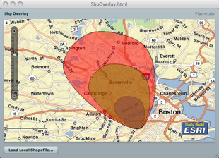
In this post, I will demo how to load a local shapefile from your hard drive, and overlay it on an map whose base layer is derived from a remote ArcGIS server. Using the Flash Player 10 FileReference API, this task is fairly easy. However, I did not want the user to be prompted for each imported file as a shapefile is composed of a .shp file holding the geometry and a .dbf file holding the attributes. So, the idea is to zip the shp and dbf and load the zip, and then let the application unzip the content and parse the shp and dbf entries. The application is using the Flex API for AGS and makes use of two wonderful as3 library; the shp library from Edwin van Rijkom , and a zip library from David Chang . In this application, I created a custom geometry to take advantage of the coordinate array format in the shapefile reducing the impedance and taking advantage of the "compression". Well, this not truly compressed - this an array of x,y,x,y,etc... rather than an array of MapP...